Most AI lives in the cloud.
Ours works in the field.
We replace manual field surveys with AI that runs on-site - drone data capture to vision models for timber yield, footfall, and industrial monitoring, grounded in geomatics-grade spatial science.
Spatial intelligence that holds the field accountable.
Currently in forestry - built to expand
Forestry Applications
Our current focus is AI-powered log counting and yield estimation - delivered through a platform where owners, loggers, and site managers can log in and track real-time field metrics as we collect data daily.
Exploring this in another sector? Get in touch.
Every log counted. Every cubic metre accounted for
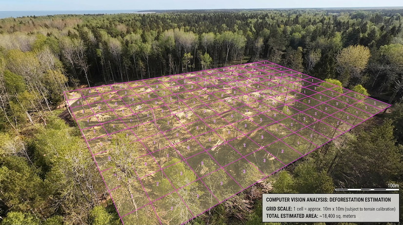
Quantify exactly how much forest was removed - and hold contractors to it.
Contractors underestimate removal. You pay the difference.
Without precise measurement, forestry owners routinely lose value to manual measurement error — averaging 6.1% across large pine consignments, with individual loads understated by as much as 8.6%.* Our satellite and drone-derived coverage analysis gives you an independent, verifiable baseline before work begins and a clear before/after comparison when it ends.
The data is timestamped, georeferenced, and exportable — usable directly in contract disputes or regulatory reporting.
* Moskalik et al. (2022). Methods of Wood Volume Determining and Its Implications for Forest Transport. Sensors, 22(16), 6028. doi:10.3390/s22166028 · Volume and price assumptions are estimates; site-specific figures will vary.
Site area: 200 ha
Growing stock: ~200 m³/ha — Estonian mature pine (national avg. 155 m³/ha across all ages; harvestable stands run higher)
Stumpage price: ~€50/m³ — derived from €65–80/m³ roadside minus ~€20–25 harvesting costs
Measurement error: 6.10% avg, 8.62% ceiling — Moskalik et al. (2022)*
At 6.1% average error
200 × 200 × €50 × 0.061 = €122,000
At 8.62% ceiling
200 × 200 × €50 × 0.0862 = €172,400
Volume and price figures are estimates. Site-specific results will vary.
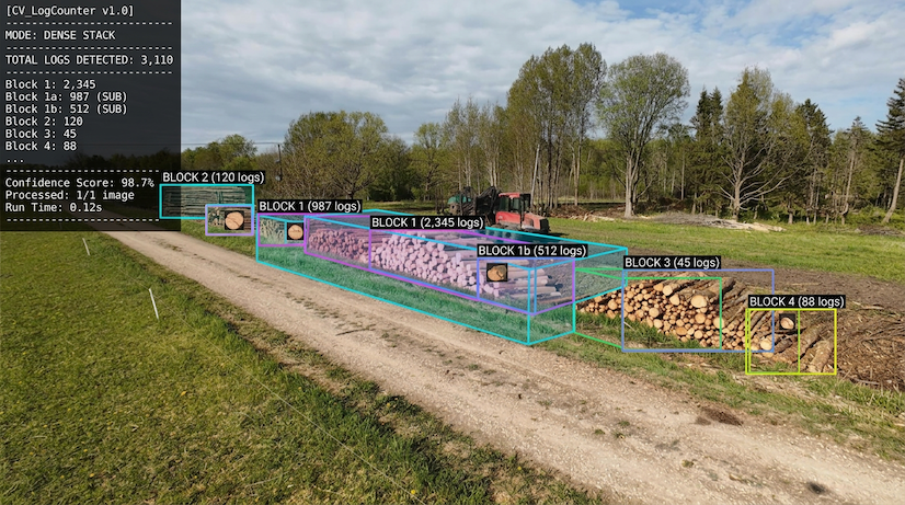
Log Count & Measurement
Computer vision models count individual logs and estimate volume from images or video - delivering accurate tallies in minutes, not days.
Income & Yield Estimation
From log count and species data, we generate projected income estimates so landowners and buyers have clear, data-backed figures before a single truck leaves the site.
Independent Validation
We act as an external validator - giving landowners, contractors, and regulators a trusted baseline. Final counts are held accountable against our upfront yield estimates, creating transparency and compliance throughout the logging process.
Other Applications
Edge computer vision
across industries
The same on-device vision technology applies well beyond forestry. If your business has a use case, we'd love to hear about it.
Logging Estimation & Yield
Aerial and ground-level vision models estimate timber volume, tree density, and harvest yield - without manual surveying.
Footfall & Heatmaps
Count customers, map movement patterns, and identify peak zones - all processed on-device. No footage leaves the store.
Perimeter Monitoring
Detect unauthorised access, loitering, or after-hours activity instantly. Runs 24/7 on a single edge device.
Visual Quality Control
Spot defects, misalignments, or packaging errors on the production line at machine speed - before products leave the floor.
Venue Capacity & Safety
Monitor crowd density and enforce occupancy limits in real time. Compliant, private, and fully on-premise.
Vehicle & Plate Detection
Track vehicle entry, exit, and dwell time across parking lots or loading bays. Automate access without expensive hardware.

51.5074° N, 0.1278° W · OPEN FOR COLLABORATION
Let's talk about your project
Whether you're exploring AI solutions, surveying services, or data platforms - reach out and we'll get back to you.